 Archeo Entry
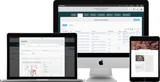
Archeological information input application
ArcheoEntry is the only information entry tool that adapts entirely to your needs. Its dynamism greatly reduces the time required for field data management and post-excavation analysis. It was designed with a very strong technological base to manage large construction sites and the simultaneous capture of a large number of users.
Forms tailored to Your Needs
Create the forms yourself or choose from a shared registry
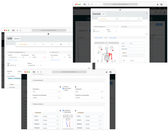
Dynamic forms
The forms are easily configurable by the user and can be easily adapted to the individual needs of each organization and each work site. There is no limit to the complexity of the forms you can create. Drag and drop down menu, simple fields, text, numeric, date, sketch, tab, table ...
Configurable table
Data in forms can be viewed in tabular form, with a selection of user-defined columns. On this basis, the data can then be easily exported in different formats (xls, csv...).
Form Register
Les formulaires créés peuvent être stockés de manière privée ou partagés avec d'autres utilisateurs ou institutions via un registre de formulaires.
Work from anywhere
Instant synchronization between worksite and office users
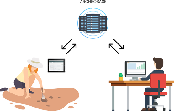
Centralized management
The web application allows live data to be synchronized regardless of the number of users on the same site. Observe the progress of the work and work from your desk.
Web interface
ArcheoBase can be used from any web browser. The user benefits from the same working environment, whether in the office or with a tablet in the field.
Single Entry
Paper input is no longer required. Entering the data only once saves a significant amount of time.
Data sharing
ArcheoBase makes it easy for institutions to share information. The user can define whether he wants to keep his data within his own institution or whether he wants to make it accessible to other users or institutions.
Group Projects
Users from different institutions or individuals can create a group project and work together.
Integrated GIS
View your geo-referenced data, view your orthophotos
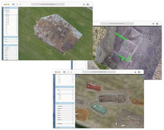
Overview and mapping
The data entered, if georeferenced, are automatically integrated into a geographic information system (GIS).
GIS Import
Topos points can be imported and displayed on the map using an import procedure from XLSX or CSV files.
Orthophotos
Uploaded orthophotos are used by the system so that they can be displayed on the map in Web mode, while maintaining a very high level of quality. The originals are always downloadable by the user.
Security
Rights, storage, availability, traceability, backup, security at all levels

Load capacity
The program is designed to handle large data loads while maintaining excellent speed of execution. The storage of data, documents and photos is unlimited.
Tracability
No information is lost. Traceability of all changes is ensured by an automatic back-up system allowing to go back in time to identify the changes made.
Computing power
Computing power is instantly available for all procedures that require a solid foundation (image processing, artificial intelligence, etc.).
Specifiable Rights
A sophisticated rights system allows users to be defined who has access to information on a job site as well as the actions (read-write-admin) assigned to them
Redundant storage
Data storage is redundant and highly secure with daily backups.
Backup Module
For those institutions that wish to do so, an automated backup and export module will be available. It will export all the information contained in ArcheoBase to another server on a regular basis.
Other features

Sketch
To facilitate sketching, the user can draw by hand on a background photo. Such a photo can be taken directly with the tablet or be called from the photo directory. Skeleton images have been pre-processed, so that the user can easily highlight the bones discovered.

Voice input
Fast and consistent input is provided through drop-down menus. This system is complemented by a voice input tool which transcribes directly into the input fields the user-dictated elements.

Tablet Sharing
In order to reduce hardware costs, users can share a single tablet in the field. A quick login system allows you to make user changes quickly.

Image recognition
A system for detecting characters on an image makes it possible to automatically link the photos taken with a reference plate and the archeological or technical units which concern them.

Multilingualism
Like all other modules of ArcheoBase, ArcheoEntry is available in different languages (French, German, English, Italian).
Looking to the future

Continuous development
New features are continuously implemented. Development priorities have been set and can be found on the "My Account" page.

Community approach
ArcheoBase is based on a participatory approach by integrating user suggestions. Technical solutions that meet the identified needs are directly implemented and made available to the entire user community.
 Stay in the Loop